20
Sep
CSIP: PRELIMS BOOSTER SERIES – 46 INTERNATIONAL RELATIONS
SIR CREEK BORDER DISPUTE
Sir Creek, a 96 km waterway nestled in the marshes of Gujarat’s Rann of Kutch, is at the heart of a contentious border dispute between India and Pakistan. This strip of water serves as a natural divider, roughly demarcating India’s Kutch region from Pakistan’s Sindh province before opening into the Arabian Sea. Interestingly, it was originally known as Ban Ganga but acquired its current name during the colonial era, paying homage to a British official.
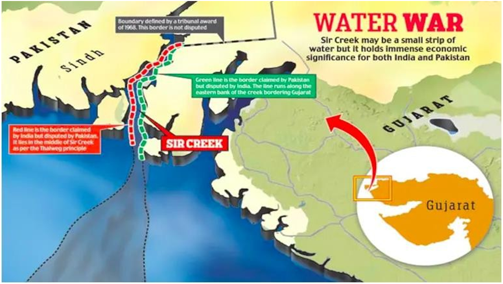
The roots of the dispute trace back to the pre-independence period when the Bombay Government Resolution of 1914 delineated the creek’s eastern flank as the boundary line, as per Pakistan’s claim (indicated by the green line).
However, India insists that the Green Line is merely indicative, preferring a boundary in line with the mid-channel principle, bolstered by a 1925 map and mid-channel pillars erected in 1924 (represented by the red line).
India’s argument is grounded in international law’s Thalweg Principle, asserting that the boundary should follow the center of the principal navigable channel, which it contends Sir Creek is during high tides. In contrast, Pakistan dismisses this, contending that the principle applies solely to navigable channels, which it insists Sir Creek is not.
The strategic importance of Sir Creek has not gone unnoticed. It was a flashpoint during the 1965 war when Indian and Pakistani troops clashed in the Rann of Kutch. Beyond its geopolitical significance, Sir Creek is a vital fishing ground, one of Asia’s largest. Furthermore, it holds potential oil and gas reserves beneath its seabed, making it a region of immense economic importance.
