CSIP: PRELIMS BOOSTER SERIES-355 SCIENCE AND TECHNOLOGY
DOPPLER WEATHER RADAR NETWORK
Why in News?
Currently, there are 39 Doppler Weather Radars (DWRs) well distributed across the country to monitor severe weather events. This information was given by the Union Minister of Earth Sciences, Shri Kiren Rijiju in a written reply in the Lok Sabha.
What is Doppler Weather Radar Network?
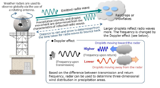
- Based on Doppler principle, the radar is designed to improve precision in long-range weather forecasting and surveillance using a parabolic dish antenna and a foam sandwich spherical radome.
- DWR has the equipment to measure rainfall intensity, wind shear and velocity and locate a storm centre and the direction of a tornado or gust front.
- Doppler effect: When the source and the signal are in relative motion to each other there is a change in the frequency observed by the observer. If they are moving closer, frequency increases and vice versa.
- Doppler radar can be divided into several different categories according to the wavelength which are L, S, C, X, K.
- With this current deployment of DWR network, India Meteorological Department (IMD) has made an immense improvement in forecasting weather events.
- The nowcast accuracy, i.e. Probability of Detection (PoD) has increased from 61% in 2014 to 91% in 2023
- the data from these DWRs are assimilated in various state-of-the-art regional and global dynamical models for generating the forecasts at various temporal and spatial scales.
- The nowcast model, viz. High-Resolution Rapid Refresh Modelling System (IMD-HRRR) and Electric Weather Research and Forecasting (EWRF) model use Radar data for prediction of rainfall and thunderstorm in 6 to 12 hours advance.