CSIP: PRELIMS BOOSTER SERIES-412 GEOGRAPHY
INLAND WATERWAYS
WHY IN NEWS?
PIB: Assessment of inland waterways in India
BACKGROUND
INLAND WATERWAYS
An inland waterway is a navigable channel used to transport goods, materials, or other movable objects. Inland waterways consist of rivers, lakes, canals and backwaters. Rivers and lakes are natural waterways, whereas canals and backwaters are artificial.
India has inland navigation waterways of 14,500 km in length. Out of these only 5685 km are navigable by mechanised vessels
INLAND WATERWAYS AUTHORITY OF INDIA
Inland Waterways Authority of India was created by the Government of India on 27 October 1986 for development and regulation of inland waterways for shipping and navigation.
The Authority primarily undertakes projects for development and maintenance of Inland Waterway Terminal infrastructure on National Waterways
It is headquartered at Noida with regional offices at Patna (Bihar), Kolkata (West Bengal), Guwahati (Assam) and Kochi (Kerala) and sub-offices at other places throughout India.
NATIONAL WATERWAYS OF INDIA
TO promote Inland Water Transport (IWT) in the country, 111 waterways (including 5 existing and 106 new) have been declared as National Waterways (NWs) under the National Waterways Act, 2016 which came into effect from 12th April, 2016.
IMPORTANT WATERWAYS IN INDIA
NW1: Prayagraj–Haldia stretch of the Ganga–Bhagirathi–Hooghly Rivers
NW2: Sadiya–Dhubri stretch of Brahmaputra River
NW3: Kollam–Kottapuram stretch of West Coast Canal and Champakara canal and Udyogmandal canal
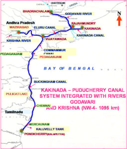
NW4: Kakinada to Puducherry (Phase-1development of the stretch Muktiyala to Vijyawada of river Krishna)
NW 5: Mahanadi delta, Talcher to Dhamra stretch of Brahmani river, east coast canal.

NW68: Mandovi River
NW 73: Narmada River
NW 97: Sunderbans waterways
NW 100: Tapi river
NW 111: Zuari river

